Maps: NYC Subway, Bus & Rail
4.7

About Maps: NYC Subway, Bus & Rail
Works without internet!
Popular choice for tourists, visitors and MyMTA commuters!
NYC SUBWAY MAPs show all train stations in great detail and include both regular & night time service.
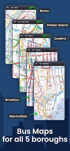
BUS MAPs for all NYC MTA bus lines in Manhattan, Brooklyn, Bronx, Queens and Staten Island.
LIRR MAP with station details of entire Long Island Railroad and connections with subway and bus.
METRO-NORTH MAP covers rail lines across 3 states of New York, New Jersey, Connecticut, also incudes parts of NJ Transit rail lines.
A comprehensive map pack for entire New York City!
2 SUBWAY MAPs:
NYC Subway Map - Regular Service
NYC Subway Night Map - Night Service
5 BUS MAPs:
Manhattan Bus Service
Brooklyn Bus Service
Queens Bus Service
Bronx Bus Service
Staten Island Bus Service
2 RAIL MAPs:
LIRR, Long Island Rail Road
Metro-North
For Schedules, Alerts, Directions on NYC Subway, MTA Bus, LIRR & Metro North download our companion app: https://play.google.com/store/apps/details?id=com.nyctrans.it
Facebook:
https://www.facebook.com/MyTransitNewYork
Twitter:
https://twitter.com/mytransitapp
Web:
http://www.mytrans.it


Recent Updates - Version 1.9.3
- NYC Subway map and LIRR map updated. New MTA Bus maps & Metro North map.
Thanks for using MyTransit Maps - for feedback, questions or tech support please reach out to us at info@mytrans.it
Install On Your Mobile Device:


Install On Windows PC Or Mac: