SpotLens - GPS camera for work
4.7

About SpotLens - GPS camera for work
SpotLens - GPS Camera & Timestamp Camera makes capturing pictures and taking notes more efficiently, combining both processes in one single app.
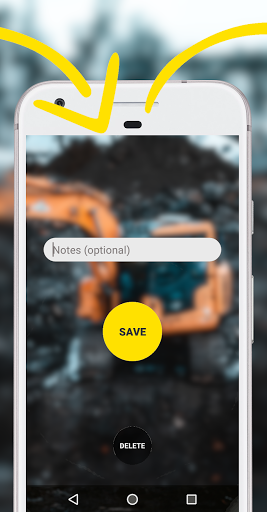
There is no need to take notes on a piece of paper while taking pictures. SpotLens will add your inserted notes automatically both to the picture and to the file name. This will give you more time to concentrate on your work, while SpotLens will take care of saving your notes and pictures combined in a lossless format onto your phone.
SpotLens works, so you can work!
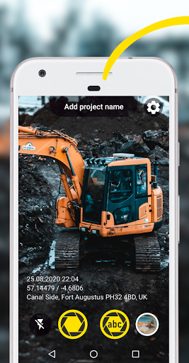
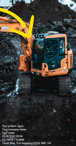
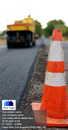
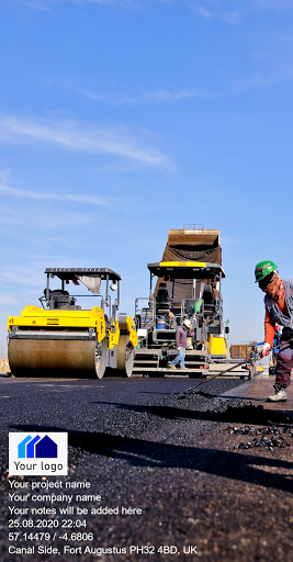
With SpotLens - GPS Camera & Timestamp Camera, you can add a project name, company name, notes and more information, for example a reference no. or chainage directly in the app while taking pictures.
Additional relevant data for professionals, e.g. GPS coordinates / photo location (latitude and longitude and multiple other coordinate formats), GPS accuracy, altitude, address, date and time (timestamp) will be added by SpotLens.
Information that can be added:
- Project name
- Taken notes
- GPS coordinates / photo location (latitude and longitude & more)
- GPS accuracy (in m or ft)
- Altitude (in m or ft)
- Date & time (timestamp)
- Address
- Compass direction
- Customized company logo
- Reference No. / Chainage
SpotLens - GPS Camera & Timestamp Camera supports the following coordinate/grid systems:
- WGS84 (latitude and longitude)
- UTM
- MGRS (NAD83)
- USNG (NAD83)
- ETRS89
- ED50
- RD (RDNAPTRANS2018)
- British National Grid (OS National Grid)
- Map Grid of Australia (MGA2020)
- Irish Grid
- Swiss Grid CH1903+ / LV95
- New Zealand Transverse Mercator 2000 (NZTM2000)
SpotLens - GPS Camera & Timestamp Camera is the ideal work camera app for land surveyors when carrying out surveys, being on the construction site or doing general land surveying.
It is the perfect work camera app for civil engineers, construction managers and other construction and civil engineering professionals when working the construction site. Civil engineers working in road engineering and highway design will be able to add chainages to their photo information.
Architects will be able to use SpotLens to document the progress on construction sites.
Geologists will be able to use SpotLens as their work camera app when doing field surveying and to document their findings.
Real estate agent and other real estate professionals will be able to use SpotLens as their work camera app for real estate and housing documentation.
Any other professional will be able to take advantage of SpotLens - GPS Camera & Timestamp Camera as their new work camera app to take pictures and notes more efficiently while saving time. SpotLens is the ideal camera for work!
SpotLens - GPS Camera & Timestamp Camera can also be used perfectly for non-work related activities such as outdoor activities, mountaineering, kayaking and more!
The GPS photo location accuracy varies depending on the device, location, surrounding environment and internet connection. SpotLens - GPS Camera & Timestamp Camera has no influence on the accuracy of the GPS data (e.g. latitude and longitude).

Recent Updates - Version 1.1.29
- Minor bug fixes. Deleting the logo is now more intuitive.
Install On Your Mobile Device:


Install On Windows PC Or Mac: